In a year that has been mostly terrible from start to finish, it is nice to end on a positive note with happy drawings of how a blighted corridor might be transformed in a deserving neighborhood.
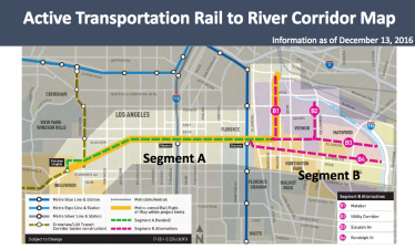
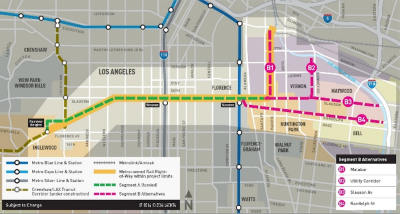
Spoiler alert: of the four options Metro is considering, the Randolph Street option (B4) has ranked the highest. Not only would it help connect residents to more schools and other important community destinations, it would be able to provide residents with the safest way to reach those destinations. Best of all, it would add over four miles to the bike/pedestrian path and connect users to the river and the existing bike path there.
This Sunday, June 26, Metro will be making their twice yearly “service changes” to bus and rail service. This typically means minor cuts, often justifiable, but still incrementally making riders’ lives a little worse and incrementally contributing to declines in ridership. Metro’s The Source has a fair summary of the agency’s latest round of transit service […]
As bike month comes to a close, we have some good news for South L.A. cyclists. At yesterday’s Metro Board meeting, a $2 million contract was awarded to Cityworks Design to begin working on plans for a 6.4 mile segment of the Rail-to-River bike path project (segments A-1, A-2, and A-3, above). The Rail-to-River bike […]
“In the interest of time,” Greg Kildare, Executive Director of Metro’s Enterprise Risk, Safety, and Asset Management team, began his address to the Board on July 23, “I will just say that staff believes that the [Metro Blue Line] pedestrian gating project is an extremely important safety improvement to our oldest rail line and consistent […]